id
Country
Country
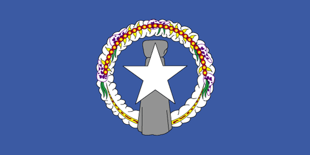
Northern Mariana Islands
Country in French
Mariannes (îles de)
countryucasefr
MARIANNES (ILES DE)
Country in Chinese
Country in Spanish
Islas De Mariana Norteñas
Country in Italian
Isole Di Mariana Del Nord
Country in Portuguese
Consoles De Mariana Do norte
Country in Germain
NordcMarianacInseln
countryfull
Northern Mariana Islands
countrynm
Northern Mariana Islands
ISO2
MP
ISO3
MNP
countrycodeisono
580
countrycodeirs
CQ
countrycodeirsfr
CQ
countrycodeirsmixt
CQ
♀Female
12
6
51
1
currencypxcode
USD
Capital
Saipan
capitalfr
Saipan
Phone Prefix
1-670
Area km2
477
arealand
477
landarablerate
0.1522
landforestrate
0.304
coastline
1482
timezonedeltabegin
10
flaglink
maplink
nmarmap.gif
visapassenger
-1
largestcity
Saipan
rankpopulation
193
Population
76 000
rankincome
222
nationalevent
Commonwealth Day
nationaleventfr
Jour du Commonwealth
nationalholiday
8 January (1978)
Birthday yyyy-mm-dd
1978-01-08 00:00:00
4
6
location
Oceania, islands in the North Pacific Ocean, about three-quarters of the way from Hawaii to the Philippines
terrain
southern islands are limestone with level terraces and fringing coral reefs; northern islands are volcanic
naturalresources
arable land, fish
cooking
The islands, which include Saipan, Rota, Farallon de Pajaros and Tinian, total some 477 square kilometers. Saipan and Tinian have the best ports and harbors. Download high resolution version (992x496, 124 KB)Large flag of the Northern Mariana Islands. ... Image taken from www. ... Flag ratio: 1:2 The flag of the Northern Mariana Islands was adopted on July 4, 1976. ... A motto is a phrase or collection of words intended to describe the motivation or intention of a sociological grouping or organization. ... locator map for the Northern Marianas - made for Wikipedia File links The following pages link to this file: Northern Mariana Islands User:DanielZm/test Roman Catholic Diocese of Chalan Kanoa Categories: Country locator maps | Northern Mariana Islands | GFDL images ... As with any complex, emergent concept, language is somewhat resistant to definition. ... The English language is a West Germanic language that originates in England. ... Chamorro, or Chamoru, is the native language used in Guam and Northern Mariana Islands. ... Carolinian is an Austronesian language spoken in the Northern Mariana Islands, where it is an official language along with English and Chamorro. ... In politics a capital (also called capital city or political capital — although the latter phrase has an alternative meaning based on an alternative meaning of capital) is the principal city or town associated with its government. ... Saipan is the largest island and capital of the Northern Mariana Islands of the western Pacific Ocean, with a total area of 120 km² (46. ... A head of state or chief of state is the chief public representative of a nation-state, federation or commonwealth, whose role generally includes personifying the continuity and legitimacy of the state and exercising the political powers, functions and duties granted to the head of state in the countrys... List of Northern Mariana Islands Governors Carlos S. Camacho Democrat 1978-1982 Pedro P. Tenorio Republican 1982-1990 Lorenzo I. De Leon Guerrero Republican 1990-1994 Froilan C. Tenorio Democrat 1994-1998 Pedro P. Tenorio Republican 1998-2002 Juan N. Babauta Republican 2002- Categories: Lists of governors of U.S... Juan Nekai Babauta (born September 7, 1953, Tapanag, Saipan) is current governor of the Northern Mariana Islands. ... This article explains the meaning of area as a physical quantity. ... Here is a list of the countries of the world sorted by area. ... (Redirected from 1 E8 m2) To help compare different orders of magnitude and geographical regions, we list here areas between 100 km² and 1000 km². See also areas of other orders of magnitude. ... Square kilometre (US spelling: Square kilometer), symbol km², is an SI unit of surface area. ... In the most common sense of the word, a population is the collection of people—or organisms of a particular species—living in a given geographic area. ... Population density can be used as a measurement of any tangible item. ... This is a list of sovereign states and other territories by population. ... Independence is autonomous self-government of a country by its residents and indigenous population. ... The dollar is the name of the official currency in several countries, dependencies and other regions (see list below), including the US dollar, the worlds most widely circulated currency (see list below). ... -1... UTC also stands for the University of Tennessee at Chattanooga Coordinated Universal Time or UTC, also sometimes referred to as Zulu time, the basis for civil time, differs by an integral number of seconds from atomic time and a fractional number of seconds from UT1. ... The National Anthem is the name of a song by the band Radiohead. ... A top-level domain (TLD) is the last part of which Internet domain names consist of. ... .mp is the Internet country code top-level domain ( ccTLD) for Northern Mariana Islands. ... Saipan is the largest island and capital of the Northern Mariana Islands of the western Pacific Ocean, with a total area of 120 km² (46. ... Rota, also known as the peaceful island, is the southernmost island of the United States Commonwealth of the Northern Mariana Islands (CNMI). ... Farallon de Pajaros (from spanish Farallón de los pájaros, meaning Birds Rock), also known as Uracas (from Spanish Urracas, meaning Ravens), is the westernmost island in the Northern Mariana Islands chain. ... Tinian is one of the three principal islands of the Commonwealth of the Northern Marianas Islands. ... (Redirected from 1 E8 m2) To help compare different orders of magnitude and geographical regions, we list here areas between 100 km² and 1000 km². See also areas of other orders of magnitude. ...
9
rgbback
16777215
todate
1