Countries/Territories
Updated 2021-01-12 18:58:07
The names of countries/territories of the world are taught in English and Chinese. This collection of precious dry lands that shares the whole mankind includes not only the world's independent countries, but also specific areas that are not a UNUnited Nations: We the peoples...A stronger UN for a better world. member. Please visit the table of male and female genders of country names in French.
Countries/locations Close
11
id
Country
Country
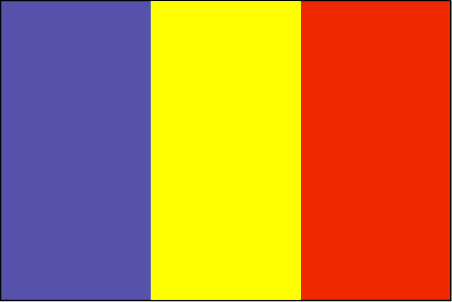
Chad
Country in French
Tchad
countryucasefr
TCHAD
Country in Chinese
Country in Spanish
Sábalo
Country in Italian
Il Ritaglio
Country in Portuguese
República do Tchad
Country in Germain
Tschad
countrypy
zha4 de2
countrylocal
Tchad
countryfull
Chad
countrynm
Chad
ISO2
TD
ISO3
TCD
countrycodeisono
148
countrycodevehicle
TCH
countrycodeolympic
CHA
countrycodeirs
CD
countrycodeirsfr
CD
countrycodeirsmixt
CD
♂Male
15
4
57
languagesfr
Arabe, Français
119
currency
franc
currencyfr
franc C.F.A.
currencyisocode
XAF
currencyisocodefull
XAF 950
currencypxcode
XAF
currencysymbol
CFAF
currencysubdivision
100 centimes
currencyregime
Euro (655.957)
currencyvalue
0.00186
nationalityfr
Chadienne
Capital
N'Djamena
capitalfr
N'Djamena
Phone Prefix
235
Area km2
1 284 000
arealand
1 259 200
areawater
24 800
landarablerate
0.0278
landforestrate
0.101
summit
Emi Koussi 3 415 m.
boundarycountries
Niger, Libye, Soudan, Centrafrique, Cameroun, Nigeria.
timezonedeltabegin
1
flaglink
maplink
tdcolor.gif
outlinemaplink
tdout.gif
visapassenger
-1
maincities
Sarh, Moundou, Abéché, Bongor, Doba, Lai, Koumra, Kélo.
largestcity
Ndjamena
largestcitypopulation
826 000
rankpopulation
83
Population
8 582 000
rankgdp
139
gdp
2608000000
rankgdpppp
123
gdpppp
10386000000
rankgni
151
gni
2073000000
rankincomeorigin
192
rankincome
206
income
240
rankincomeppp
185
incomeppp
1080
lifeexpectation
48.24
alphabetizationrate
0.46
natalityrate
0.0465
mortalityrate
0.01638
mortalityrateinfantile
0.09478
hdi
0.376
urbanization
0.241
nationalevent
Independence Day
nationaleventfr
Jour de l'Indépendance
nationalholiday
11 August (1960)
Birthday yyyy-mm-dd
1960-08-11 00:00:00
7
1
location
Central Africa, south of Libya
terrain
broad, arid plains in center, desert in north, mountains in northwest, lowlands in south
naturalresources
petroleum (unexploited but exploration under way),
9
Web
rgbback
16777215
todate
1
12
id
Country
Country
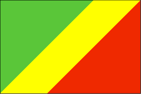
Congo
Country in French
Congo
countryucasefr
CONGO
Country in Chinese
Country in Spanish
Congo
Country in Italian
Il Congo
Country in Portuguese
Congo
Country in Germain
Der Kongo
countrypy
gang1 guo3 gong4 he2 guo2
countrylocal
République du Congo
countryfull
Congo, Republic of the
countrynm
Congo, Republic of the
ISO2
CG
ISO3
COG
countrycodeisono
178
countrycodevehicle
RCB
countrycodeolympic
CGO
countrycodeirs
CF
countrycodeirsfr
CF
countrycodeirsmixt
CF
♂Male
15
57
languagesfr
Français
119
currency
franc
currencyfr
franc C.F.A.
currencyisocode
XAF
currencyisocodefull
XAF 950
currencypxcode
XAF
currencysymbol
CFAF
currencysubdivision
100 centimes [*]
currencyregime
Euro (655.957)
currencyvalue
0.00186
nationalityfr
Congolaise
Capital
Brazzaville
capitalfr
Brazzaville
Phone Prefix
242
Area km2
342 000
arealand
341 500
areawater
500
landarablerate
0.005
coastline
169
summit
Monts de la Lékéti 1 040 m.
boundarycountries
Gabon, Cameroun, Centrafrique, Congo démocratique, Angola.
timezonedeltabegin
1
flaglink
maplink
cgcolor.gif
outlinemaplink
cgout.gif
visapassenger
-1
maincities
Pointe Noire, N'Kayi, Loubomo, Ngamaba-Mfilou, Loandjili, Massendjo.
largestcity
Brazzaville
rankpopulation
126
Population
3 757 000
rankgdp
130
gdp
3564000000
rankgdpppp
148
gdpppp
3625000000
rankgni
147
gni
2443000000
rankincomeorigin
153
rankincome
167
income
650
rankincomeppp
200
incomeppp
730
lifeexpectation
50.02
alphabetizationrate
0.566
natalityrate
0.02946
mortalityrate
0.0142
mortalityrateinfantile
0.09534
nationalevent
Independence Day
nationaleventfr
Jour de l'Indépendance
nationalholiday
15 August (1960)
Birthday yyyy-mm-dd
1960-08-15 00:00:00
7
1
location
Western Africa, bordering the South Atlantic Ocean, between Angola and Gabon
terrain
coastal plain, southern basin, central plateau, northern basin
naturalresources
petroleum, timber, potash, lead, zinc, uranium, co
9
Web
rgbback
16777215
todate
1
13
id
Country
Country
Cote d'Ivory
Country in French
Côte d'Ivoire
countryucasefr
COTE D'IVOIRE
Country in Chinese
Country in Spanish
Cote D'Ivoire (Costa de Marfil)
Country in Italian
Cote D'Ivoire (Costa D'avorio)
Country in Portuguese
Cote D'Ivoire (Costa De Marfim)
Country in Germain
Cote D'Ivoire (Die Elfenbeinküste)
countrypy
ke1 te4 di2 wa3
countrylocal
Cote d'Ivoire
countryfull
Cote d'Ivoire
countrynm
Cote d'Ivoire
ISO2
CI
ISO3
CIV
countrycodeisono
384
countrycodevehicle
CI
countrycodeolympic
CIV
countrycodeirs
IV
countrycodeirsfr
IV
countrycodeirsmixt
IV
countrycode
225
♀Female
15
4
57
languagesfr
Français
119
currency
franc
currencyfr
franc C.F.A.
currencyisocode
XOF
currencyisocodefull
XOF 952
currencypxcode
XOF
currencysymbol
CFAF
currencysubdivision
100 centimes
currencyregime
Euro (655.957)
currencyvalue
0.00186
nationality
Côte d'Ivoire
nationalityfr
Ivoirienne
Capital
Yamoussoukro
capitalfr
Yamoussoukro
Phone Prefix
225
Area km2
322 462
arealand
318 000
areawater
4 460
landarablerate
0.0928
landforestrate
0.224
coastline
515
summit
Mont Nimba 1 752 m.
boundarycountries
Burkina Faso, Liberia, Guinée, Mali, Ghana.
flaglink

maplink
cicolor.gif
outlinemaplink
ciout.gif
visapassenger
-1
maincities
Abidjan, Bouaké, Daloa, Man, Danané, Korhogo, Gagnoa.
largestcity
Yamoussoukro
largestcitypopulation
2 793 000
rankpopulation
55
Population
16 835 000
rankgdp
83
gdp
13734000000
rankgdpppp
91
gdpppp
24857000000
rankgni
86
gni
11124000000
rankincomeorigin
152
rankincome
166
income
660
rankincomeppp
180
incomeppp
1400
lifeexpectation
44.72
alphabetizationrate
0.538
natalityrate
0.03999
mortalityrate
0.01674
mortalityrateinfantile
0.09223
nationalevent
Independence Day
nationaleventfr
Jour de l'Indépendance
nationalholiday
7 August (1960)
Birthday yyyy-mm-dd
1960-08-07 00:00:00
7
1
location
Western Africa, bordering the North Atlantic Ocean, between Ghana and Liberia
terrain
mostly flat to undulating plains; mountains in northwest
naturalresources
petroleum, natural gas, diamonds, manganese, iron
cooking
Fruits Tropicaux.
9
Web
rgbback
16777215
todate
1
Notes
Fruits Tropicaux. Capital noted is official, Abidjan (de facto)
14
id
Country
Country
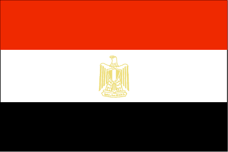
Egypt
Country in French
Egypte
countryucasefr
EGYPTE
Country in Chinese
Country in Spanish
Egipto
Country in Italian
L'Egitto
Country in Portuguese
Egipto
Country in Germain
Ägypten
countrypy
ai1 ji2
countrylocal
Misr
countryfull
Egypt
countrynm
Egypt
ISO2
EG
ISO3
EGY
countrycodeisono
818
countrycodevehicle
ET
countrycodeolympic
EGY
countrycodeirs
EG
countrycodeirsfr
EG
countrycodeirsmixt
EG
countrycode
20
♀Female
15
4
3
languagesfr
Arabe
36
currency
pound
currencyfr
livre égyptienne
currencyisocode
EGP
currencyisocodefull
EGP 818
currencypxcode
EGP
currencysymbol
£E
currencysubdivision
100 piasters or 1,000 milliemes
currencyregime
m.float
currencyvalue
0.173
nationalityfr
Egyptienne
Capital
Cairo
capitalfr
Le Caire
Phone Prefix
20
Area km2
1 001 449
arealand
995 450
areawater
6 000
landarablerate
0.0285
landforestrate
0.001
coastline
2450
summit
Jabal Katrînah 2 642 m
boundarycountries
Libye, Israël, Palestine, Soudan.
timezonedeltabegin
2
flaglink
maplink
egcolor.gif
outlinemaplink
egout.gif
visapassenger
-1
maincities
Alexandrie, Ismaïlia, Gîza, Port Saïd, Assiout, Helwân, Tanta, El Mahlla el Kubra, Zagazig, El Mansoura, Suez, Assouan.
largestcity
Cairo
largestcitypopulation
9 690 000
rankpopulation
17
Population
67 559 000
rankgdp
42
gdp
82427000000
rankgdpppp
29
gdpppp
266853000000
rankgni
38
gni
93850000000
rankincomeorigin
126
rankincome
138
income
1390
rankincomeppp
132
incomeppp
3940
lifeexpectation
70.41
alphabetizationrate
0.484
natalityrate
0.02436
mortalityrate
0.00535
mortalityrateinfantile
0.03526
nationalevent
Revolution Day
nationaleventfr
Jour de le Révolution
nationalholiday
23 July (1952)
Birthday yyyy-mm-dd
1952-07-23 00:00:00
9
5
location
Northern Africa, bordering the Mediterranean Sea, between Libya and the Gaza Strip, and the Red Sea north of Sudan, and includes the Asian Sinai Peninsula
terrain
vast desert plateau interrupted by Nile valley and delta
naturalresources
petroleum, natural gas, iron ore, phosphates, mang
9
Web
rgbback
16777215
todate
1
15
id
Country
Country
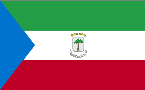
Equatorial Guinea
Country in French
Guinée équatoriale
countryucasefr
GUINEE EQUATORIALE
Country in Chinese
Country in Spanish
Guinea Ecuatorial
Country in Italian
Guinea Equatoriale
Country in Portuguese
Guinea Equatorial
Country in Germain
Äquatoriale Guine
countrypy
chi4 dao4 ji3 nei4 ya4
countrylocal
Guinea Ecuatorial
countryfull
Equatorial Guinea
countrynm
Equatorial Guinea
ISO2
GQ
ISO3
GNQ
countrycodeisono
226
countrycodeolympic
GEQ
countrycodeirs
EK
countrycodeirsfr
EK
countrycodeirsmixt
EK
♀Female
15
4
131
languagesfr
Espagnol
119
currency
franc
currencyfr
franc C.F.A.
currencyisocode
GQE
currencyisocodefull
GQE 226
currencypxcode
GQE
currencysymbol
CFAF
currencysubdivision
100 centimos
currencyregime
Euro (655.957)
nationalityfr
Guinéenne
Capital
Malabo
capitalfr
Malabo
Phone Prefix
240
Area km2
28 051
arealand
28 051
landarablerate
0.0463
landforestrate
0.625
coastline
296
summit
Pico de Santa Isabel 3 008 m.
boundarycountries
Cameroun, Gabon.
timezonedeltabegin
1
flaglink
maplink
gqcolor.gif
outlinemaplink
gqout.gif
visapassenger
-1
maincities
Bata, Luba, Mbini, Evinayong, Ebebiyin, Mongono.
largestcity
Malabo
largestcitypopulation
30 000
rankpopulation
161
Population
494 000
rankgdp
135
gdp
2915000000
rankgdpppp
128
gdpppp
8988000000
rankgni
195
gni
327000000
rankincomeorigin
150
rankincome
165
income
700
rankincomeppp
116
incomeppp
5100
lifeexpectation
55.15
alphabetizationrate
0.85
natalityrate
0.03656
mortalityrate
0.01227
mortalityrateinfantile
0.08708
hdi
0.664
urbanization
0.493
nationalevent
Independence Day
nationaleventfr
Jour de l'Indépendance
nationalholiday
12 October (1968)
Birthday yyyy-mm-dd
1968-10-12 00:00:00
5
9
location
Western Africa, bordering the Bight of Biafra, between Cameroon and Gabon
terrain
coastal plains rise to interior hills; islands are volcanic
naturalresources
oil, petroleum, timber, small unexploited deposits
9
Web
rgbback
16777215
todate
1
16
id
Country
Country
Eritrea
Country in French
Erythrée
countryucasefr
ERYTHREE
Country in Chinese
Country in Spanish
Eritrea
Country in Italian
Eritrea
Country in Portuguese
Eritrea
Country in Germain
Eritrea
countrypy
e4 li4 te4 li3 ya4
countrylocal
Hagere Ertra
countryfull
Eritrea
countrynm
Eritrea
ISO2
ER
ISO3
ERI
countrycodeisono
232
countrycodeolympic
ERI
countrycodeirs
ER
countrycodeirsfr
ER
countrycodeirsmixt
ER
♀Female
7
1
3
languagesfr
Tigrinya, Arabe
134
currency
nakfa
currencyisocode
ERN
currencyisocodefull
ERN 232
currencypxcode
ERN
currencysymbol
Nfa
currencysubdivision
100 cents
Capital
Asmara
capitalfr
Asmara
Phone Prefix
291
Area km2
121 320
arealand
121 320
landarablerate
0.0387
landforestrate
0.135
coastline
2234
summit
Soira 3 013 m.
boundarycountries
Djibouti, Ethiopie, Soudan.
timezonedeltabegin
3
flaglink
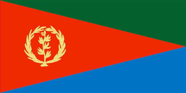
maplink
ercolor.gif
outlinemaplink
erout.gif
visapassenger
-1
maincities
Massawa, Aseb.
largestcity
Asmara
largestcitypopulation
431 000
rankpopulation
116
Population
4 390 000
rankgdp
160
gdp
751000000
rankgdpppp
147
gdpppp
3727000000
rankgni
175
gni
851000000
rankincomeorigin
198
rankincome
212
income
190
rankincomeppp
190
incomeppp
1020
lifeexpectation
52.7
alphabetizationrate
0.578
natalityrate
0.03903
mortalityrate
0.01336
mortalityrateinfantile
0.07559
hdi
0.446
urbanization
0.191
nationalevent
Independence Day
nationaleventfr
Jour de l'Indépendance
nationalholiday
24 May (1993)
Birthday yyyy-mm-dd
1993-05-24 00:00:00
10
10
location
Eastern Africa, bordering the Red Sea, between Djibouti and Sudan
terrain
dominated by extension of Ethiopian north-south trending highlands, descending on the east to a coastal desert plain, on the northwest to hilly terrain and on the southwest to flat-to-rolling plains
naturalresources
gold, potash, zinc, copper, salt, possibly oil and
9
rgbback
16777215
todate
1
17
id
Country
Country
Ethiopia
Country in French
Ethiopie
countryucasefr
ETHIOPIE
Country in Chinese
Country in Spanish
Etiopía
Country in Italian
L'Etiopia
Country in Portuguese
Etiópia
Country in Germain
Äthiopien
countrypy
ai3 sai4 e2 bi3 ya4
countrylocal
Ityop'iya
countryfull
Ethiopia
countrynm
Ethiopia
ISO2
ET
ISO3
ETH
countrycodeisono
231
countrycodevehicle
ETH
countrycodeolympic
ETH
countrycodeirs
ET
countrycodeirsfr
ET
countrycodeirsmixt
ET
♀Female
4
181
languagesfr
Amharique
135
currency
birr
currencyfr
Birr
currencyisocode
ETB
currencyisocodefull
ETB 230
currencypxcode
ETB
currencysymbol
Br
currencysubdivision
100 cents
currencyregime
float
currencyvalue
0.1154
nationalityfr
Ethiopienne
Capital
Addis Abeba
capitalfr
Addis Abeba
Phone Prefix
251
Area km2
1 127 127
arealand
1 119 683
areawater
7 444
landarablerate
0.099
landforestrate
0.042
summit
Ras Dashen Terara 4 620 m.
boundarycountries
Soudan, Erythrée, Djibouti, Somalie, Somaliland, Kenya.
timezonedeltabegin
3
flaglink
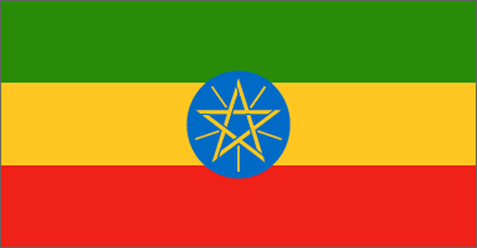
maplink
etcolor.gif
outlinemaplink
etout.gif
visapassenger
-1
maincities
Gonder, Dire Dawa, Dessié, Jimma, A Nazret, Harar, Mak'alé, Bahir Dar.
largestcity
Addis Abeba
largestcitypopulation
2 431 000
rankpopulation
16
Population
68 613 000
rankgdp
106
gdp
6652000000
rankgdpppp
68
gdpppp
48780000000
rankgni
108
gni
6355000000
rankincomeorigin
207
rankincome
220
income
90
rankincomeppp
201
incomeppp
710
lifeexpectation
41.24
alphabetizationrate
0.2766
natalityrate
0.03981
mortalityrate
0.02017
mortalityrateinfantile
0.10322
nationalevent
National Day (defeat of MENGISTU regime)
nationaleventfr
Jour National
nationalholiday
28 May (1991)
Birthday yyyy-mm-dd
1991-05-28 00:00:00
8
8
location
Eastern Africa, west of Somalia
terrain
high plateau with central mountain range divided by Great Rift Valley
naturalresources
small reserves of gold, platinum, copper, potash,
9
Web
rgbback
16777215
todate
1
18
id
Country
Country
Europa Island
Country in French
Ile d'Europe
countryucasefr
ILE D'EUROPE
Country in Chinese
Country in Spanish
Isla De Europa
Country in Italian
Isola Di Europa
Country in Portuguese
Console De Europa
Country in Germain
Insel Europa
countryfull
Europa Island
countrynm
Europa Island
ISO2
REUE
ISO3
REUE
countrycodeisono
638
countrycodeirs
EU
countrycodeirsfr
EU
countrycodeirsmixt
IDE
♀Female
15
6
57
2
currencypxcode
EUR
Phone Prefix
262
Area km2
30
arealand
28
coastline
22.2
flaglink
maplink
eu-map.gif
visapassenger
-1
rankincome
222
location
Southern Africa, island in the Mozambique Channel, about one-half of the way from southern Madagascar to southern Mozambique
terrain
low and flat
naturalresources
NEGL
cooking
Southern Africa, island in the Mozambique Channel, about one-half of the way from southern Madagascar to southern Mozambique
9
rgbback
16777215
todate
1
19
id
Country
Country
Gabon
Country in French
Gabon
countryucasefr
GABON
Country in Chinese
Country in Spanish
Gabón
Country in Italian
Il Gabon
Country in Portuguese
Gabon
Country in Germain
Gabun
countrypy
jia1 peng2
countrylocal
Gabon
countryfull
Gabon
countrynm
Gabon
ISO2
GA
ISO3
GAB
countrycodeisono
266
countrycodevehicle
G
countrycodeolympic
GAB
countrycodeirs
GB
countrycodeirsfr
GB
countrycodeirsmixt
GB
♂Male
15
4
57
languagesfr
Français
119
currency
franc
currencyfr
franc C.F.A.
currencyisocode
XAF
currencyisocodefull
XAF 950
currencypxcode
XAF
currencysymbol
CFAF
currencysubdivision
100 centimes [*]
currencyregime
Euro (655.957)
currencyvalue
0.00186
nationalityfr
Française
Capital
Libreville
capitalfr
Libreville
Phone Prefix
241
Area km2
267 667
arealand
257 667
areawater
10 000
landarablerate
0.0126
landforestrate
0.847
coastline
885
summit
Mont Iboudji 1 580 m.
boundarycountries
Guinée équatoriale, Cameroun, Congo.
timezonedeltabegin
1
flaglink
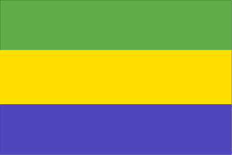
maplink
gacolor.gif
outlinemaplink
gaout.gif
visapassenger
-1
maincities
Port Gentil, Lambarené, Mouila, Tchibanga, Oyem.
largestcity
Libreville
largestcitypopulation
419 000
rankpopulation
148
Population
1 344 000
rankgdp
111
gdp
6057000000
rankgdpppp
131
gdpppp
8600000000
rankgni
124
gni
4489000000
rankincomeorigin
89
rankincome
99
income
3340
rankincomeppp
110
incomeppp
5500
lifeexpectation
56.46
alphabetizationrate
0.71
natalityrate
0.0364
mortalityrate
0.01143
mortalityrateinfantile
0.05434
hdi
0.653
urbanization
0.823
precipitation
2841
nationalevent
Founding of the Gabonese Democratic Party (PDG)
nationaleventfr
Création du Parti Démocratique Gabonais
nationalholiday
12 March (1968)
Birthday yyyy-mm-dd
1968-03-12 00:00:00
5
9
location
Western Africa, bordering the Atlantic Ocean at the Equator, between Republic of the Congo and Equatorial Guinea
terrain
narrow coastal plain; hilly interior; savanna in east and south
naturalresources
petroleum, manganese, uranium, gold, timber, iron
9
Web
rgbback
16777215
todate
1
20
id
Country
Country
Gambia, The
Country in French
Gambie
countryucasefr
GAMBIE
Country in Chinese
Country in Spanish
Gambia
Country in Italian
La Gambia
Country in Portuguese
Gambia
Country in Germain
Gambia
countrypy
gang1 bi3 ya4
countrylocal
The Gambia
countryfull
Gambia, The
countrynm
Gambia, The
ISO2
GM
ISO3
GMB
countrycodeisono
270
countrycodevehicle
WAG
countrycodeolympic
GAM
countrycodeirs
GA
countrycodeirsfr
GA
countrycodeirsmixt
GA
♀Female
15
4
51
languagesfr
Anglais
136
currency
dalasi
currencyfr
Dalasi
currencyisocode
GMD
currencyisocodefull
GMD 270
currencypxcode
GMD
currencysymbol
D
currencysubdivision
100 butut
currencyregime
float
currencyvalue
0.03663
nationalityfr
Gambienne
Capital
Banjul
capitalfr
Banjul
Phone Prefix
220
Area km2
11 295
arealand
10 000
areawater
1 300
landarablerate
0.195
landforestrate
0.481
coastline
80
summit
53 m.
boundarycountries
Sénégal.
flaglink

maplink
gmcolor.gif
outlinemaplink
gmout.gif
visapassenger
-1
maincities
Serrekunda, Brikama, Bakau, Farafenni, Guntur, Sukuta.
largestcity
Banjul
largestcitypopulation
186 000
rankpopulation
146
Population
1 421 000
rankgdp
170
gdp
395000000
rankgdpppp
151
gdpppp
2641000000
rankgni
191
gni
387000000
rankincomeorigin
189
rankincome
203
income
270
rankincomeppp
169
incomeppp
1740
lifeexpectation
54.79
alphabetizationrate
0.3905
natalityrate
0.0403
mortalityrate
0.01208
mortalityrateinfantile
0.07348
hdi
0.463
urbanization
0.536
nationalevent
Independence Day
nationaleventfr
Jour de l'Indépendance
nationalholiday
18 February (1965)
Birthday yyyy-mm-dd
1965-02-18 00:00:00
2
6
location
Western Africa, bordering the North Atlantic Ocean and Senegal
terrain
flood plain of the Gambia River flanked by some low hills
naturalresources
fish
9
Web
rgbback
16777215
todate
1
| Countries/Territories | Regions of China | Provinces of China | Regions in France | French Departments | States/Provinces | Cities/Towns | Locations | World Continents | French AOP Wines
