Pays/Territoires
Mise à jour 2021-01-12 18:58:56
Les noms des pays/territoires du monde sont donnés en Français et Chinois. Cette collection des précieuses terres fermes du monde que toute l'humanité partage inclut non seulement les pays indépendants, mais aussi des régions spécifiques qui ne sont pas membre de l'ONUOrganisation des Nations Unies: Nous, peuples des Nations Unies ... Une ONU plus forte pour un monde meilleur. Veuillez aussi consulter les noms des pays en masculin et féminin en Français.
GéoPays Fermer
1
id
Pays
Pays en Anglais
American Samoa
Pays
Samoa Americaines
countryucasefr
SAMOA AMERICAINES
Pays en Chinois
Pays en Espagnol
Samoa Americana
Pays en Italien
Le Samoa americane
Pays en Portugais
Samoa Americanas
Pays en Allemand
Amerikanische Samoa-Inseln
countryfull
American Samoa
countrynm
American Samoa
ISO2
AS
ISO3
ASM
countrycodeisono
016
countrycodeolympic
ASA
countrycodeirs
AQ
countrycodeirsfr
AQ
countrycodeirsmixt
AQ
♀Féminin
17
6
51
languagesfr
Anglais
6
currency
dollar
currencyfr
dollar
currencyisocode
USD
currencyisocodefull
USD 840
currencypxcode
USD
currencysymbol
$
currencysubdivision
100 cents
currencyregime
float
currencyvalue
1
nationalityfr
Andorrane
Capitale
Pago
capitalfr
Pago
Préfixe Tél.
1-684
Superficie km2
201
arealand
199
landarablerate
0.05
landforestrate
0.601
coastline
116
timezonedeltabegin
-11
flaglink

maplink
ascolor.gif
outlinemaplink
tutuila.gif
visapassenger
-1
largestcity
Pago
rankpopulation
198
Population
57 000
rankincome
222
nationalevent
Flag Day
nationaleventfr
Jour du Drapeau
nationalholiday
17 April (1900)
Date de naissance aaaa-mm-jj
1900-04-17 00:00:00
7
1
location
Oceania, group of islands in the South Pacific Ocean, about half way between Hawaii and New Zealand
terrain
five volcanic islands with rugged peaks and limited coastal plains, two coral atolls (Rose Island, Swains Island)
naturalresources
pumice, pumicite
9
rgbback
16777215
special
Yes
todate
1
2
id
Pays
Pays en Anglais
Aruba
Pays
Aruba
countryucasefr
ARUBA
Pays en Chinois
Pays en Espagnol
Aruba
Pays en Italien
Aruba
Pays en Portugais
Aruba
Pays en Allemand
Aruba
countrypy
a1 lu2 ba1
countrylocal
Aruba
countryfull
Aruba
countrynm
Aruba
ISO2
AW
ISO3
ABW
countrycodeisono
533
countrycodeolympic
ARU
countrycodeirs
AA
countrycodeirsfr
AA
countrycodeirsmixt
AA
♀Féminin
18
6
51
9
currency
guilder (a.k.a. florin or gulden)
currencyisocode
AWG
currencyisocodefull
AWG 533
currencypxcode
AWG
currencysymbol
Afl.
currencysubdivision
100 cents
currencyregime
US-$ (1.79)
currencyvalue
0.565
Capitale
Oranjestad
capitalfr
Oranjestad
Préfixe Tél.
297
Superficie km2
180
arealand
193
landarablerate
0.1053
coastline
68.5
timezonedeltabegin
-4
flaglink
maplink
awcolor.gif
outlinemaplink
aw.gif
visapassenger
-1
largestcity
Oranjestad
rankpopulation
189
Population
99 000
rankgdp
144
gdp
1875000000
rankgni
161
gni
1230000000
rankincomeorigin
46
rankincome
47
income
12300
lifeexpectation
78.98
natalityrate
0.01153
mortalityrate
0.00647
mortalityrateinfantile
0.00602
growthrate
0.0396
hdi
0.738
nationalevent
Flag Day
nationaleventfr
Jour du Drapeau
nationalholiday
18 March
Date de naissance aaaa-mm-jj
2000-03-18 00:00:00
7
5
location
Caribbean, island in the Caribbean Sea, north of Venezuela
terrain
flat with a few hills; scant vegetation
naturalresources
NEGL; white sandy beaches
9
rgbback
16777215
todate
1
3
id
Pays
Pays en Anglais
Ashmore and Cartier Islands
Pays
Iles d'Ashmore & Cartier
countryucasefr
ILES D'ASHMORE & CARTIER
Pays en Chinois
Pays en Espagnol
Islas De Ashmore Y De Cartier
Pays en Italien
Isole Di Cartier & Di Ashmore
Pays en Portugais
Consoles De Ashmore & De Cartier
Pays en Allemand
Inseln Ashmore U. Cartier
countryfull
Ashmore and Cartier Islands
countrynm
Ashmore and Cartier Islands
ISO2
AUSA
ISO3
AUSA
countrycodeisono
036
countrycodevehicle
AUS
countrycodeolympic
AUS
countrycodeirs
AT
countrycodeirsfr
AT
countrycodeirsmixt
AT
♀Féminin
12
7
51
10
currencypxcode
AUD
Préfixe Tél.
61
Superficie km2
5
arealand
5
coastline
74.1
timezonedeltabegin
8
flaglink
maplink
ashmore.jpg
visapassenger
-1
rankincome
222
president
Reine Elizabeth II
location
Southeastern Asia, islands in the Indian Ocean, northwest of Australia, south of the Indonesian half of Timor island
terrain
low with sand and coral
naturalresources
fish
9
rgbback
16777215
todate
1
4
id
Pays
Pays en Anglais
Azores
Pays
Açores
countryucasefr
ACORES
Pays en Chinois
Pays en Espagnol
Azores
Pays en Italien
Le Azzorre
Pays en Portugais
Açores
Pays en Allemand
Azoren
countryfull
Azores
countrynm
Azores
ISO2
PRTA
ISO3
PRTA
countrycodeisono
620
countrycodevehicle
P
countrycodeolympic
POR
countrycodeirs
PO
countrycodeirsfr
PO
countrycodeirsmixt
ACR
♀Féminin
18
6
114
languagesfr
Portugais
2
currencyfr
euro
currencypxcode
EUR
currencysymbol
€
Capitale
Santa Cruz (Sao Miguel)
capitalfr
Santa Cruz (Sao Miguel)
Préfixe Tél.
351
Superficie km2
2 247
summit
Peak of the volcano of Pico attains a height of 2 351 m
timezonedeltabegin
-1
flaglink
maplink
azoresne.gif
outlinemaplink
azores.gif
visapassenger
-1
largestcity
Santa Cruz (Sao Miguel)
Population
237 800
rankincome
222
cooking
The islands are São Miguel, Santa Maria, Terceira, Graciosa, São Jorge, Pico, Faial, Flores and Corvo.
7
Web
rgbback
16777215
todate
1
5
id
Pays
Pays en Anglais
Baker Island
Pays
Ile Baker
countryucasefr
ILE BAKER
Pays en Chinois
Pays en Espagnol
Isla Del Panadero
Pays en Italien
Isola Del Panettiere
Pays en Portugais
Console Do Padeiro
Pays en Allemand
BäckercInsel
countryfull
Baker Island
countrynm
Baker Island
ISO2
UMI6
ISO3
UMI6
countrycodeisono
581
countrycodeirs
FQ
countrycodeirsfr
FQ
countrycodeirsmixt
FQ
♀Féminin
17
7
51
1
currencypxcode
USD
Superficie km2
1,40
arealand
1,40
coastline
4.8
timezonedeltabegin
-12
flaglink
maplink
baker-island-map.gif
visapassenger
-1
rankincome
222
location
Oceania, atoll in the North Pacific Ocean, about half way between Hawaii and Australia
terrain
low, nearly level coral island surrounded by a narrow fringing reef
naturalresources
guano (deposits worked until 1891), terrestrial an
9
rgbback
16777215
todate
1
6
id
Pays
Pays en Anglais
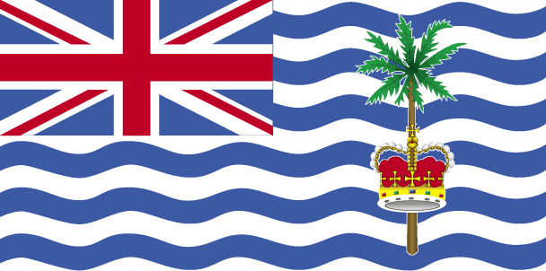
British Indian Ocean Territory
Pays
Territoire Britanique Océan Indien
countryucasefr
TERRITOIRE BRITANIQUE OCEAN INDIEN
Pays en Chinois
Pays en Espagnol
Territorio Del Océano Indio Del Br
Pays en Italien
Territorio Dell'Oceano Indiano Del Br
Pays en Portugais
Território Do Oceano Indian Do Br
Pays en Allemand
Gegend Des Indischen Ozeans Des Brs
countryfull
British Indian Ocean Territory
countrynm
British Indian Ocean Territory
ISO2
GBRB
ISO3
GBRB
countrycodeisono
826
countrycodeolympic
GBR
countrycodeirs
IO
countrycodeirsfr
IO
countrycodeirsmixt
IO
♂Masulin
12
6
51
22
currency
pound
currencyfr
livre sterling
currencyisocode
GBP
currencyisocodefull
GBP 826
currencypxcode
GBP
currencysymbol
£
currencysubdivision
100 pence
currencyregime
float
currencyvalue
1.8091
Préfixe Tél.
44
Superficie km2
60
arealand
60
coastline
698
timezonedeltabegin
6
flaglink
maplink
biot.gif
visapassenger
-1
rankincome
222
president
Reine Elizabeth II
location
archipelago in the Indian Ocean, south of India, about one-half the way from Africa to Indonesia
terrain
flat and low (most areas do not exceed four meters in elevation)
naturalresources
coconuts, fish, sugarcane
9
rgbback
16777215
todate
1
7
id
Pays
Pays en Anglais
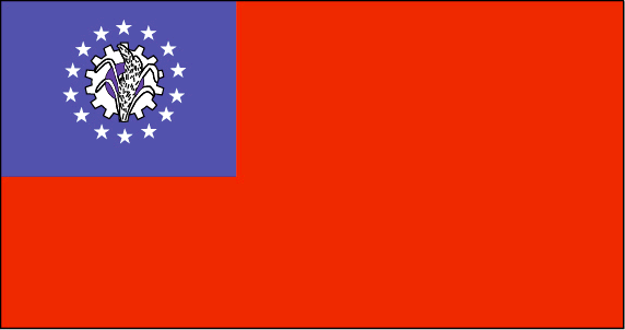
Myanmar
Pays
Birmanie
countryucasefr
BIRMANIE
Pays en Chinois
Pays en Espagnol
Birmania
Pays en Italien
La Birmania
Pays en Portugais
Burma
Pays en Allemand
Birma
countrypy
mian3 dian4
countrylocal
Myanma Naingngandaw
countryfull
Burma
countrynm
Burma
ISO2
MM
ISO3
MMR
countrycodeisono
104
countrycodevehicle
BUR
countrycodeolympic
MYA
countrycodeirs
BM
countrycodeirsfr
BM
countrycodeirsmixt
BM
♀Féminin
2
1
30
languagesfr
Birman
120
currency
kyat
currencyfr
kyat
currencyisocode
MMK
currencyisocodefull
MMK 104
currencypxcode
MMK
currencysymbol
K
currencysubdivision
100 pyas
currencyregime
US-$ (5.86of, 200-300bm)
currencyvalue
0.1599
Capitale
Rangoon
capitalfr
Rangoon
Préfixe Tél.
95
Superficie km2
676 552
arealand
657 740
areawater
20 760
landarablerate
0.1453
landforestrate
0.523
coastline
1930
summit
Hkakabo Razi 5 881 m.
boundarycountries
Bangladesh, Inde, Tibet, Chine, Laos, Thaïlande.
timezonedeltabegin
6.5
flaglink
maplink
mmcolor.gif
outlinemaplink
mmout.gif
visapassenger
-1
maincities
Mandalay, Moulmein, Pegu, Bassein, Akyab, Myeik.
largestcity
Yangon
largestcitypopulation
3 873 000
rankpopulation
24
Population
49 363 000
rankgni
38
gni
92900000000
rankincomeorigin
117
rankincome
126
income
1896
lifeexpectation
55.79
alphabetizationrate
0.806
natalityrate
0.01915
mortalityrate
0.01217
mortalityrateinfantile
0.07035
precipitation
2681
nationalevent
Independence Day
nationaleventfr
Jour de l'Indépendance
nationalholiday
4 January (1948)
Date de naissance aaaa-mm-jj
1948-01-04 00:00:00
4
12
location
Southeastern Asia, bordering the Andaman Sea and the Bay of Bengal, between Bangladesh and Thailand
terrain
central lowlands ringed by steep, rugged highlands
naturalresources
petroleum, timber, tin, antimony, zinc, copper, tu
9
rgbback
16777215
todate
1
8
id
Pays
Pays en Anglais
Canary Islands
Pays
Canarie (îles)
countryucasefr
CANARIE (ILES)
Pays en Chinois
Pays en Espagnol
Canarias
Pays en Italien
Delle Canarie
Pays en Portugais
Consoles Amarelos
Pays en Allemand
Kanarische Inseln
countryfull
Canary Islands
countrynm
Canary Islands
ISO2
ESPC
ISO3
ESPC
countrycodeisono
724
countrycodevehicle
E
countrycodeolympic
ESP
countrycodeirs
SP
countrycodeirsfr
SP
countrycodeirsmixt
CNR
♀Féminin
11
7
131
2
currencyfr
euro
currencypxcode
EUR
currencysymbol
€
Capitale
Las Palmas
capitalfr
Las Palmas
Préfixe Tél.
34
Superficie km2
7 242
timezonedeltabegin
1
flaglink
maplink
canarynw.gif
outlinemaplink
canary.gif
visapassenger
-1
largestcity
Las Palmas
Population
1 672 689
rankincome
222
7
rgbback
16777215
todate
1
9
id
Pays
Pays en Anglais
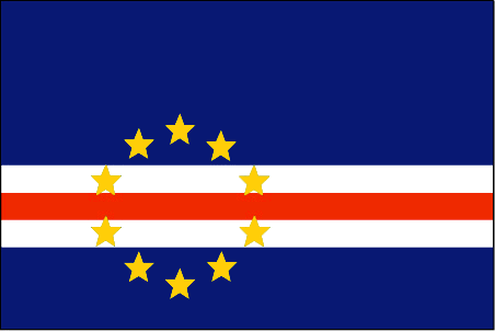
Cape Verde
Pays
Cap-Vert
countryucasefr
CAP-VERT
Pays en Chinois
Pays en Espagnol
Cabo Verde
Pays en Italien
Cape Verde
Pays en Portugais
Cape Verde
Pays en Allemand
Cape Verde
countrypy
fo2 de2 jiao3
countrylocal
Cabo Verde
countryfull
Cape Verde
countrynm
Cape Verde
ISO2
CV
ISO3
CPV
countrycodeisono
132
countrycodeolympic
CPV
countrycodeirs
CV
countrycodeirsfr
CV
countrycodeirsmixt
CV
♂Masulin
15
6
114
languagesfr
Portugais
2
currency
escudo
currencyfr
escudo du Cap Vert
currencyisocode
CVE
currencyisocodefull
CVE 132
currencypxcode
CVE
currencysymbol
C.V.Esc.
currencysubdivision
100 centavos
currencyregime
composite
currencyvalue
0.01107
Capitale
Praia
capitalfr
Praia
Préfixe Tél.
238
Superficie km2
4 033
arealand
4 033
landarablerate
0.0968
landforestrate
0.211
coastline
965
summit
Pico 2 829 m.
timezonedeltabegin
-1
flaglink
maplink
cvcolor
outlinemaplink
cvout.gif
visapassenger
-1
maincities
Mindelo, Ribeira Grande, Sal, Santa Maria.
largestcity
Praia
largestcitypopulation
68 000
rankpopulation
162
Population
470 000
rankgdp
157
gdp
797000000
rankgdpppp
152
gdpppp
2449000000
rankgni
183
gni
675000000
rankincomeorigin
124
rankincome
136
income
1440
rankincomeppp
115
incomeppp
5130
lifeexpectation
70.14
alphabetizationrate
0.768
natalityrate
0.02613
fecondity
3.3
mortalityrate
0.00672
mortalityrateinfantile
0.04914
hdi
0.727
urbanization
0.635
nationalevent
Independence Day
nationaleventfr
Jour de l'Indépendance
nationalholiday
5 July (1975)
Date de naissance aaaa-mm-jj
1975-07-05 00:00:00
2
4
location
Western Africa, group of islands in the North Atlantic Ocean, west of Senegal
terrain
steep, rugged, rocky, volcanic
naturalresources
salt, basalt rock, limestone, kaolin, fish
9
Web
rgbback
16777215
todate
1
10
id
Pays
Pays en Anglais
Christmas Island
Pays
Ile Christmas (Océan Indien)
countryucasefr
ILE CHRISTMASS (OCEAN INDIEN)
Pays en Chinois
Pays en Espagnol
Isla De Navidad (Océano De la India)
Pays en Italien
Isola Di Natale (Oceano Dell'India)
Pays en Portugais
Console Do Christmas (Oceano De India)
Pays en Allemand
WeihnachtscInsel (IndiencOzean)
countryfull
Christmas Island
countrynm
Christmas Island
ISO2
CX
ISO3
CXR
countrycodeisono
162
countrycodeirs
KT
countrycodeirsfr
KT
countrycodeirsmixt
KT
♀Féminin
12
6
51
10
currency
dollar
currencyisocode
AUD
currencyisocodefull
AUD 036
currencypxcode
AUD
currencysymbol
A$
currencysubdivision
100 cents
currencyregime
float
currencyvalue
0.7485
Préfixe Tél.
61
Superficie km2
135
arealand
135
coastline
80
timezonedeltabegin
-7
flaglink
maplink
xmas.gif
visapassenger
-1
Population
1 685
rankincome
222
president
Reine Elizabeth II
location
Southeastern Asia, island in the Indian Ocean, south of Indonesia
terrain
steep cliffs along coast rise abruptly to central plateau
naturalresources
phosphate, beaches
9
rgbback
16777215
todate
1
| Pays/Territoires | Régions en Chine | Provinces de Chine | Régions en France | Départements de France | Provinces du Monde | Villes/Villages | Localités | Continents du Monde | Vins AOP
