Pays/Territoires
Mise à jour 2021-01-12 18:58:56
Les noms des pays/territoires du monde sont donnés en Français et Chinois. Cette collection des précieuses terres fermes du monde que toute l'humanité partage inclut non seulement les pays indépendants, mais aussi des régions spécifiques qui ne sont pas membre de l'ONUOrganisation des Nations Unies: Nous, peuples des Nations Unies ... Une ONU plus forte pour un monde meilleur. Veuillez aussi consulter les noms des pays en masculin et féminin en Français.
GéoPays Fermer
21
id
Pays
Pays en Anglais
Howland Island
Pays
Ile Howland
countryucasefr
ILE HOWLAND
Pays en Chinois
Pays en Espagnol
Isla De Howland
Pays en Italien
Isola Di Howland
Pays en Portugais
Console De Howland
Pays en Allemand
Insel Howland
countryfull
Howland Island
countrynm
Howland Island
ISO2
UMI8
ISO3
UMI8
countrycodeisono
581
countrycodeirs
HQ
countrycodeirsfr
HQ
countrycodeirsmixt
HQ
♀Féminin
17
7
51
1
currencypxcode
USD
Superficie km2
1,84
arealand
1,60
coastline
6.4
timezonedeltabegin
-12
flaglink
maplink
howland.gif
visapassenger
-1
rankincome
222
location
Oceania, island in the North Pacific Ocean, about half way between Hawaii and Australia
terrain
low-lying, nearly level, sandy, coral island surrounded by a narrow fringing reef; depressed central area
naturalresources
guano (deposits worked until late 1800s), terrestr
cooking
Oceania, island in the North Pacific Ocean, about half way between Hawaii and Australia
9
rgbback
16777215
todate
1
22
id
Pays
Pays en Anglais
Johnston Atoll
Pays
Atoll Johnston
countryucasefr
ATOLL JOHNSTON
Pays en Chinois
Pays en Espagnol
Johnston Atoll
Pays en Italien
Johnston Atoll
Pays en Portugais
Johnston Atoll
Pays en Allemand
Johnston Atoll
countryfull
Johnston Atoll
countrynm
Johnston Atoll
ISO2
UMI7
ISO3
UMI7
countrycodeisono
581
countrycodeirs
JQ
countrycodeirsfr
JQ
countrycodeirsmixt
JQ
♂Masulin
17
7
51
6
currency
dollar
currencyisocode
USD
currencyisocodefull
USD 840
currencypxcode
USD
currencysymbol
$
currencysubdivision
100 cents
currencyregime
float
currencyvalue
1
Superficie km2
2,80
arealand
2,80
coastline
34
timezonedeltabegin
-10
flaglink
maplink
jq-map.gif
visapassenger
-1
rankincome
222
location
Oceania, atoll in the North Pacific Ocean 717 NM (1328 km) southwest of Honolulu, Hawaii, about one-third of the way from Hawaii to the Marshall Islands
terrain
mostly flat
naturalresources
guano deposits worked until depletion about 1890,
cooking
Oceania, atoll in the North Pacific Ocean 717 NM (1328 km) southwest of Honolulu, Hawaii, about one-third of the way from Hawaii to the Marshall Islands
9
rgbback
16777215
todate
1
23
id
Pays
Pays en Anglais
Kingman Reef
Pays
Récif Kingman
countryucasefr
RECIF KINGMAN
Pays en Chinois
Pays en Espagnol
Filón De Kingman
Pays en Italien
Reef Di Kingman
Pays en Portugais
Recife De Kingman
Pays en Allemand
Reef Kingman
countryfull
Kingman Reef
countrynm
Kingman Reef
ISO2
UMI9
ISO3
UMI9
countrycodeisono
581
countrycodeirs
KQ
countrycodeirsfr
KQ
countrycodeirsmixt
KQ
♂Masulin
17
7
51
1
currencypxcode
USD
Superficie km2
1
arealand
1
coastline
3
timezonedeltabegin
-11
flaglink
maplink
kq-map.gif
visapassenger
-1
rankincome
222
location
Oceania, reef in the North Pacific Ocean, about half way between Hawaii and American Samoa
terrain
low and nearly level
naturalresources
terrestrial and aquatic wildlife
cooking
Oceania, reef in the North Pacific Ocean, about half way between Hawaii and American Samoa
9
rgbback
16777215
todate
1
24
id
Pays
Pays en Anglais
Kiribati
Pays
Kiribati
countryucasefr
KIRIBATI
Pays en Chinois
Pays en Espagnol
Kiribati
Pays en Italien
Kiribati
Pays en Portugais
Kiribati
Pays en Allemand
Kiribati
countrypy
ji2 li3 ba1 si1
countrylocal
Kiribati, Kiribas
countryfull
Kiribati
countrynm
Kiribati
ISO2
KI
ISO3
KIR
countrycodeisono
296
countrycodeolympic
KIR
countrycodeirs
KR
countrycodeirsfr
KR
countrycodeirsmixt
KRB
♂Masulin
15
6
51
languagesfr
Anglais
10
currency
dollar
currencyfr
dollar australien
currencyisocode
AUD
currencyisocodefull
AUD 036
currencypxcode
AUD
currencysymbol
A$
currencysubdivision
100 cents
currencyregime
float
currencyvalue
0.7485
Capitale
Tarawa
capitalfr
Tarawa
Préfixe Tél.
686
Superficie km2
717
arealand
811
landforestrate
0.384
coastline
1143
summit
Joes Hill 81 m.
timezonedeltabegin
12
flaglink
maplink
kicolor.gif
visapassenger
-1
maincities
Ooma.
largestcity
Tarawa
rankpopulation
190
Population
96 000
rankgdp
185
gdp
55000000
rankgni
207
gni
83000000
rankincomeorigin
144
rankincome
157
income
860
lifeexpectation
61.32
natalityrate
0.03099
fecondity
3.6
mortalityrate
0.00849
mortalityrateinfantile
0.0499
growthrate
0.0225
nationalevent
Independence Day
nationaleventfr
Jour de l'Indépendance
nationalholiday
12 July (1979)
Date de naissance aaaa-mm-jj
1979-07-12 00:00:00
6
8
location
Oceania, group of 33 coral atolls in the Pacific Ocean, straddling the equator; the capital Tarawa is about one-half of the way from Hawaii to Australia; note - on 1 January 1995, Kiribati proclaimed that all of its territory lies in the same time zone as
terrain
mostly low-lying coral atolls surrounded by extensive reefs
naturalresources
phosphate (production discontinued in 1979)
9
rgbback
16777215
todate
1
25
id
Pays
Pays en Anglais
Marshall Islands
Pays
Marshall (îles)
countryucasefr
MARSHALL (ILES)
Pays en Chinois
Pays en Espagnol
Forme Las Islas
Pays en Italien
Ordini Le Isole
Pays en Portugais
Marshall Consoles
Pays en Allemand
Marshall Inseln
countryfull
Marshall Islands
countrynm
Marshall Islands
ISO2
MH
ISO3
MHL
countrycodeisono
584
countrycodeolympic
MHL
countrycodeirs
RM
countrycodeirsfr
RM
countrycodeirsmixt
RM
♀Féminin
19
6
51
languagesfr
Anglais
1
currencyfr
dollar
currencysymbol
$
Capitale
Majuro
capitalfr
Uliga
Préfixe Tél.
692
Superficie km2
181,30
arealand
181,30
landarablerate
0.1667
coastline
370.4
summit
10 m.
timezonedeltabegin
12
flaglink
maplink
mhcolor.gif
outlinemaplink
mh.gif
visapassenger
-1
maincities
Ebeye
largestcity
Majuro
largestcitypopulation
28 000
rankpopulation
200
Population
53 000
rankgdp
183
gdp
106000000
rankgni
205
gni
142000000
rankincomeorigin
96
rankincome
106
income
2710
lifeexpectation
70.01
alphabetizationrate
0.937
natalityrate
0.03352
fecondity
4.02
mortalityrate
0.00488
mortalityrateinfantile
0.02945
growthrate
0.02274
hdi
0.738
urbanization
0.6618
nationalevent
Constitution Day
nationaleventfr
Jour de la Constitution
nationalholiday
1 May (1979)
Date de naissance aaaa-mm-jj
1979-05-01 00:00:00
6
8
location
Oceania, group of atolls and reefs in the North Pacific Ocean, about one-half of the way from Hawaii to Australia
terrain
low coral limestone and sand islands
naturalresources
coconut products, marine products, deep seabed min
9
rgbback
16777215
todate
1
26
id
Pays
Pays en Anglais
Micronesia, Federated States of
Pays
Micronésie
countryucasefr
MICRONESIE
Pays en Chinois
Pays en Espagnol
Micronesia, estados federados de
Pays en Italien
La Micronesia, condizioni federated di
Pays en Portugais
Micronesia, estados federados de
Pays en Allemand
Mikronesien, zu einem Bündnis vereingigte Zustände von
countryfull
Micronesia, Federated States of
countrynm
Micronesia, Federated States of
ISO2
FM
ISO3
FSM
countrycodeisono
583
countrycodeolympic
FSM
countrycodeirs
FM
countrycodeirsfr
FM
countrycodeirsmixt
FM
♀Féminin
19
7
51
languagesfr
Anglais
6
currency
dollar
currencyfr
dollar
currencyisocode
USD
currencyisocodefull
USD 840
currencypxcode
USD
currencysymbol
$
currencysubdivision
100 cents
currencyregime
float
currencyvalue
1
nationalityfr
Micronésienne
Capitale
Palikir
capitalfr
Palikir
Préfixe Tél.
691
Superficie km2
707
arealand
702
landarablerate
0.0571
landforestrate
0.217
coastline
6112
summit
Totolom 791 m.
timezonedeltabegin
10
flaglink
maplink
fmcolor.gif
outlinemaplink
fm.gif
visapassenger
-1
maincities
Pohnpei, Yap.
largestcity
Palikir
rankpopulation
184
Population
125 000
rankgdp
179
gdp
243000000
rankgni
198
gni
258000000
rankincomeorigin
109
rankincome
119
income
2070
lifeexpectation
69.44
alphabetizationrate
0.895
natalityrate
0.0258
fecondity
3.8
mortalityrate
0.00497
mortalityrateinfantile
0.03128
urbanization
0.286
nationalevent
Constitution Day
nationaleventfr
Jour de la Constitution
nationalholiday
10 May (1979)
Date de naissance aaaa-mm-jj
1979-05-10 00:00:00
6
8
location
Oceania, island group in the North Pacific Ocean, about three-quarters of the way from Hawaii to Indonesia
terrain
islands vary geologically from high mountainous islands to low, coral atolls; volcanic outcroppings on Pohnpei, Kosrae, and Chuuk
naturalresources
forests, marine products, deep-seabed minerals
9
rgbback
16777215
todate
1
27
id
Pays
Pays en Anglais
Midway Islands
Pays
Iles de Midway
countryucasefr
ILES DE MIDWAY
Pays en Chinois
Pays en Espagnol
Islas Situado a mitad del camino
Pays en Italien
Isole Intermedie
Pays en Portugais
Consoles Intermediários
Pays en Allemand
Mittlere Inseln
countryfull
Midway Islands
countrynm
Midway Islands
ISO2
UMI3
ISO3
UMI3
countrycodeisono
581
countrycodeirs
MQ
countrycodeirsfr
MQ
countrycodeirsmixt
MQ
♀Féminin
17
7
51
6
currency
dollar
currencyisocode
USD
currencyisocodefull
USD 840
currencypxcode
USD
currencysymbol
$
currencysubdivision
100 cents
currencyregime
float
currencyvalue
1
Superficie km2
6,20
arealand
6,20
coastline
15
timezonedeltabegin
-10
flaglink
maplink
mq-map.gif
visapassenger
-1
rankincome
222
location
Oceania, atoll in the North Pacific Ocean, about one-third of the way from Honolulu to Tokyo
terrain
low, nearly level
naturalresources
wildlife, terrestrial and aquatic
cooking
Oceania, atoll in the North Pacific Ocean, about one-third of the way from Honolulu to Tokyo
9
rgbback
16777215
todate
1
28
id
Pays
Pays en Anglais
Nauru
Pays
Nauru
countryucasefr
NAURU
Pays en Chinois
Pays en Espagnol
Nauru
Pays en Italien
Il Nauru
Pays en Portugais
Nauru
Pays en Allemand
Nauru
countrypy
nao4 lu3
countrylocal
Nauru
countryfull
Nauru
countrynm
Nauru
ISO2
NR
ISO3
NRU
countrycodeisono
520
countrycodevehicle
NAU
countrycodeolympic
NRU
countrycodeirs
NR
countrycodeirsfr
NR
countrycodeirsmixt
NR
♂Masulin
15
6
186
languagesfr
Nauru
10
currency
dollar
currencyfr
dollar australien
currencyisocode
AUD
currencyisocodefull
AUD 036
currencypxcode
AUD
currencysymbol
A$
currencysubdivision
100 cents
currencyregime
float
currencyvalue
0.7485
Capitale
Yaren District
capitalfr
Yaren
Préfixe Tél.
674
Superficie km2
21
arealand
21
coastline
30
summit
61 m.
timezonedeltabegin
12
flaglink
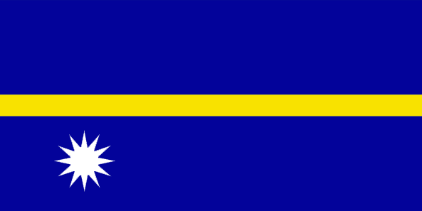
maplink
nrcolor.gif
outlinemaplink
nr.gif
visapassenger
-1
maincities
Anabar, Anibare, Anna, Ijuw, Uaboe, Yangor.
largestcity
Yaren District
largestcitypopulation
10 000
rankpopulation
220
Population
12 809
rankgni
205
gni
140000000
rankincomeorigin
48
rankincome
52
income
11667
lifeexpectation
62.33
natalityrate
0.02561
mortalityrate
0.00695
mortalityrateinfantile
0.01014
urbanization
1
nationalevent
Independence Day
nationaleventfr
Jour de l'Indépendance
nationalholiday
31 January (1968)
Date de naissance aaaa-mm-jj
1968-01-31 00:00:00
5
9
location
Oceania, island in the South Pacific Ocean, south of the Marshall Islands
terrain
sandy beach rises to fertile ring around raised coral reefs with phosphate plateau in center
naturalresources
phosphates, fish
9
rgbback
16777215
todate
1
29
id
Pays
Pays en Anglais
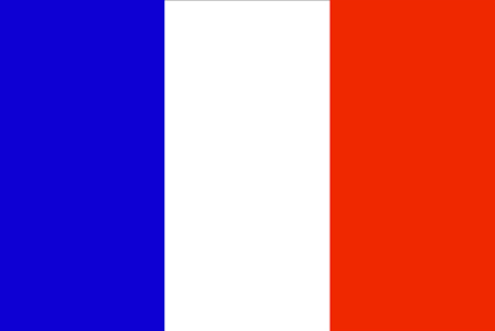
New Caledonia
Pays
Nouvelle-Calédonie
countryucasefr
NOUVELLE-CALEDONIE
Pays en Chinois
Pays en Espagnol
Caledonia Nuevo
Pays en Italien
Nuovo Caledonia
Pays en Portugais
Caledonia Novo
Pays en Allemand
Neues Caledonia
countrypy
xin1 ka1 li3 duo1 ni2 ya4
countrylocal
Nouvelle-Calédonie
countryfull
New Caledonia
countrynm
New Caledonia
ISO2
NC
ISO3
NCL
countrycodeisono
540
countrycodeirs
NC
countrycodeirsfr
NC
countrycodeirsmixt
NC
♀Féminin
18
6
57
languagesfr
Français
2
currency
franc
currencyfr
euro
currencyisocode
XPF
currencyisocodefull
XPF 953
currencypxcode
XPF
currencysymbol
CFPF (Comp
currencysubdivision
100 centimes
currencyregime
Euro (119.253)
currencyvalue
0.01025
nationalityfr
Française
Capitale
Nouméa
capitalfr
Nouméa
Préfixe Tél.
687
Superficie km2
19 060
arealand
18 575
areawater
485
landarablerate
0.0038
landforestrate
0.204
coastline
2254
summit
Mont Panié 1 682 m..
timezonedeltabegin
11
flaglink
maplink
nwcalmap.gif
outlinemaplink
grandmap.gif
visapassenger
-1
maincities
Dumbéa, Canala, Bourail, Thio, Hienghène, Houaïlu, Koumac, Kone
largestcity
Nouméa
rankpopulation
175
Population
225 000
rankgni
136
gni
3270000000
rankincomeorigin
37
rankincome
38
income
14864
lifeexpectation
73.78
alphabetizationrate
0.97
natalityrate
0.01898
fecondity
2.35
mortalityrate
0.00564
mortalityrateinfantile
0.00789
growthrate
0.01334
urbanization
0.75
nationalevent
Bastille Day
nationaleventfr
Jour de la prise de la Bastille
nationalholiday
14 July (1789)
Date de naissance aaaa-mm-jj
1789-07-14 00:00:00
6
10
location
Oceania, islands in the South Pacific Ocean, east of Australia
terrain
coastal plains with interior mountains
naturalresources
nickel, chrome, iron, cobalt, manganese, silver, g
2
Web
rgbback
16777215
todate
1
30
id
Pays
Pays en Anglais
New Zealand
Pays
Nouvelle-Zélande
countryucasefr
NOUVELLE-ZELANDE
Pays en Chinois
Pays en Espagnol
Zealand Nuevo
Pays en Italien
La Nuova Zelanda
Pays en Portugais
Zealand Novo
Pays en Allemand
Neues Seeland
countrypy
xin1 xi1 lan2
countrylocal
Aotearoa
countryfull
New Zealand
countrynm
New Zealand
ISO2
NZ
ISO3
NZL
countrycodeisono
554
countrycodevehicle
NZ
countrycodeolympic
NZL
countrycodeirs
NZ
countrycodeirsfr
NZ
countrycodeirsmixt
NZ
♀Féminin
18
6
51
languagesfr
Anglais, Maori
75
currency
dollar
currencyfr
dollar néo-zélandais
currencyisocode
NZD
currencyisocodefull
NZD 554
currencypxcode
NZD
currencysymbol
NZ$
currencysubdivision
100 cents
currencyregime
float
currencyvalue
0.6966
nationalityfr
Nouvelle Zélandaise
Capitale
Wellington
capitalfr
Wellington
Préfixe Tél.
64
Superficie km2
268 676
landarablerate
0.058
landforestrate
0.297
coastline
15134
summit
Mount Cook 3 764 m.
timezonedeltabegin
12
flaglink
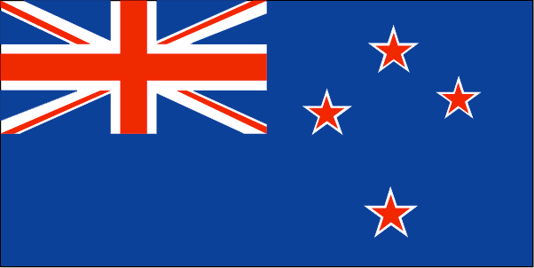
maplink
nzcolor.gif
outlinemaplink
nz.gif
maincities
Auckland, Christchurch, Napier-Hastings, Dunedin, Hamilton, Waitemata, Palmerston North, Invercargill, New Plymouth, Nelson, Whangarei, Whanganui.
largestcity
Auckland
largestcitypopulation
945 000
rankpopulation
121
Population
4 009 000
rankgdp
45
gdp
79572000000
rankgdpppp
57
gdpppp
90538000000
rankgni
48
gni
62249000000
rankincomeorigin
40
rankincome
34
income
15530
rankincomeppp
36
incomeppp
21350
lifeexpectation
78.5
alphabetizationrate
0.99
natalityrate
0.0146
mortalityrate
0.007
mortalityrateinfantile
0.0055
hdi
0.777
urbanization
0.434
precipitation
1120
nationalevent
Waitangi Day (Treaty of Waitangi established British sovereignty over New Zealand)
nationaleventfr
Jour Waitangi
nationalholiday
6 February (1840)
Date de naissance aaaa-mm-jj
1840-02-06 00:00:00
7
1
location
Oceania, islands in the South Pacific Ocean, southeast of Australia
terrain
predominately mountainous with some large coastal plains
naturalresources
natural gas, iron ore, sand, coal, timber, hydropo
cooking
Fruits de Mer
9
Web
rgbback
16777215
todate
1
Notes
Fruits de Mer
| Pays/Territoires | Régions en Chine | Provinces de Chine | Régions en France | Départements de France | Provinces du Monde | Villes/Villages | Localités | Continents du Monde | Vins AOP
